
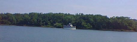
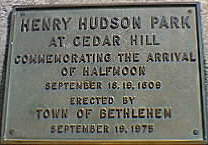
A Revolutionary Week Along the Historic Champlain Canal begins 18 miles south of the entrance to the canal on the Hudson River east of Henry Hudson Park at Cedar Hill in the town of Bethlehem, NY.
 DAY
1, Mile Mark 0.0 — Cedar Hill. Prior to the 19th Century, the river was
main-street America. Today, Cedar Hill is an historic place on this street. One
of its first visitors was the Dutch explorer, Henry Hudson, as documented by a
marker near the American Flag in the park.
DAY
1, Mile Mark 0.0 — Cedar Hill. Prior to the 19th Century, the river was
main-street America. Today, Cedar Hill is an historic place on this street. One
of its first visitors was the Dutch explorer, Henry Hudson, as documented by a
marker near the American Flag in the park.
During the Revolution, the area was home to Colonel Francis Nicoll. Nicoll served in the New York Militia from 1775-1778. He participated in the extraction of cannon and munitions from New York City, prior to its taking by the British in 1776. He also participated in the defense of Albany from Burgoyne’s invasion from Canada in 1777.
Although not visible from the Hudson, Nicoll’s home still stands at Cedar Hill. Today, it is in private hands. Near the home is a small cemetery where Col. Nicoll is buried. Also buried in the cemetery are seven other Revolutionary War soldiers, including Lt. Arie Van Wie. Van Wie’s point is another historic place on the Hudson and is two miles further north.
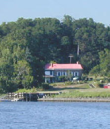 Mile
Mark 1.7 — Staat Point. On the eastern shore is historic Staat Point. The
Staat family took ownership of the point in 1688. The Staat home, which is
clearly visible from the Hudson, has been held by the Staat family since the
17th century and is still held by the family today. It is one of the oldest
homes on the Hudson River.
Mile
Mark 1.7 — Staat Point. On the eastern shore is historic Staat Point. The
Staat family took ownership of the point in 1688. The Staat home, which is
clearly visible from the Hudson, has been held by the Staat family since the
17th century and is still held by the family today. It is one of the oldest
homes on the Hudson River.
Mile Mark 2.3 — Van Wie Point. On the western shore is the historic Van Wie Point. It was settled by the Van Wie family in the mid 1600’s. Later, it became a popular docking area for passengers going to Albany due to shallows, which made docking in Albany hazardous. Dredging corrected the problem in the early 20th century.
Mile Mark 3.8 — Glenmont. To the west is the town of Glenmont where the Abbey Hotel once stood. During the Revolution, it was owned by Hugh Jolley, who emigrated from Galway, Scotland in 1772. The hotel was an important way station between Albany and Van Wie Point. It was raised in the 1960’s.
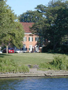 Mile
Mark 6.3 — Fort Crailo. On the eastern shore is a distinctive, 18th century
home built by the Van Rensselaer family that overlooks the river. It is the
legendary home of the patriotic song “Yankee Doodle,” penned during the
French and Indian War. During the Revolution, the fort was a staging area for
the Americans during the British invasion of 1777. Today, Fort Crailo is a
state-owned museum that depicts early Dutch life in the upper Hudson River
Valley. It is a recommended stop on a longer visit to the area.
Mile
Mark 6.3 — Fort Crailo. On the eastern shore is a distinctive, 18th century
home built by the Van Rensselaer family that overlooks the river. It is the
legendary home of the patriotic song “Yankee Doodle,” penned during the
French and Indian War. During the Revolution, the fort was a staging area for
the Americans during the British invasion of 1777. Today, Fort Crailo is a
state-owned museum that depicts early Dutch life in the upper Hudson River
Valley. It is a recommended stop on a longer visit to the area.
Mile Mark 6.8 — US Route 9 and 20 Bridge. On the western shore, docked near the bridge is the USS Slater and the Dutch Apple II. The Slater is a destroyer escort ship that saw service during World War II. Today, it is a floating museum. The Dutch Apple II is a small cruise ship that tours the Hudson in the Albany area. Both are recommended experiences on a longer visit to the area.
Mile Mark 7.3 — Hudson River Way Pedestrian Bridge. On the western shore is a recently completed walkway that connects downtown Albany with the park on the Hudson called the Corning Preserve.
Mile Mark 7.8 — Amtrak Railroad Bridge. To the east is the Albany train station in the city of Rensselaer. The bridge connects Albany with Chicago to the west and Canada to the north. Amtrak also serves Boston to the east and New York City to the south.
Mile Mark 8.0 — Corning Preserve Dock and Boat Ramp. Dock here for a short walking tour of Albany.